 water level time series
 discharge time series
 constant discharge
 pump station
The course exercise is a case study of the river Vidå, which is located in the South of Denmark at the border to Germany in a region of salt marshes.
Please read the general description of this region and have look on Vidå Photo before you start to work on the case study.
The Vidå river has been modeled in an earlier project using the DHI software product Mike11 for the time period of 1st August 1990 to 1st October 1990. The structures in use 1990 are defined in the original data set.
The HydroWeb exercise is a case study, based on this model. Of course this is a theoretical, academic study without any relation to the actual river management in this region.
The case study is based on the original model. We removed all structures and changed some of the data. The objective of the exercise is to adapt this basic model for specified new boundary conditions and requirements to propose a suitable river management model for the time period of 1st September to 1st October 1990.
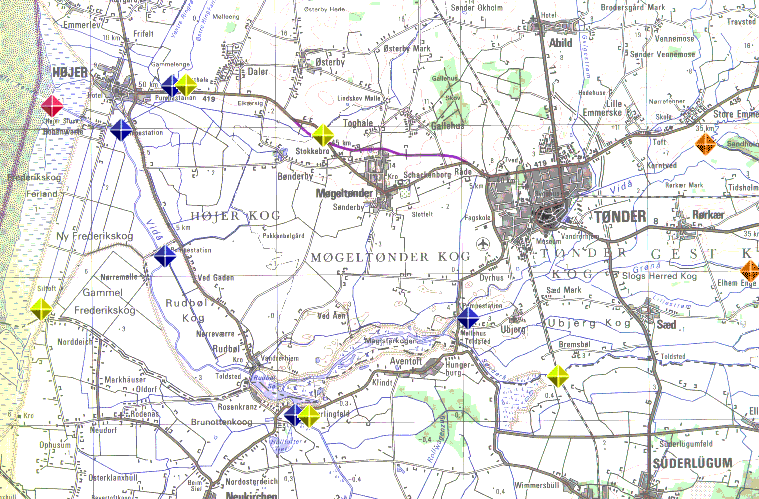
The Vidå river model has some characteristic locations for boundary conditions:
| water level time series
|
| discharge time series
|
| constant discharge
|
| pump station
|
Two pump stations have been considered in the given
model by constant discharge boundary conditiona.
The other pump stations are not considered in the model.
The modeling tasks are structured in three parts: model set-up, model optimization and model study.
First task is to adapt the given river model to a list of predefined model information:
After the latest measurements of the Vidå River cross sections, minor morphology changes have been discovered in the main channel (VIDAA-NED and VIDAA-Mel) due to a sediment transport (siltation). Please modify the cross sections at specified chainages respectively by sand filling, which should result in an elevation of the channel bottom level as defined below:
| River name | chainage | elevation |
| VIDAA-NED | 103, 556 m | 23 cm |
| VIDAA-NED | 2359, 2797 m | 25 cm |
| VIDAA-MEL | 2968, 3252 m | 20 cm |
| VIDAA-MEL | 3466, 3660 m | 30 cm |
Some discharge values (boundary conditions) have to be modified:
| River name | chainage | constant discharge |
| LINDSKOV | 1.0 m | Q= 0.60 m³/s for the whole period |
| SONDERAA | 0.0 m | Q= 0.65 m³/s for 1st Sep to 15th Sep
Q= 0.95 m³/s for 16th Sep to 1st Oct |
Hydrological events increased the amount of water in the drainage system of Højer Kog, Rudbøl Kog and Møgeltønder Kog area as well as Brunottenkoog and Hülltofter Tief on the German side. There is an urgent need to discharge the excessive drainage water from this polder area into the Vidå River during the modeling period by the existing pump stations at the end of the collecting channels. (see the map and photos).
You should consider the following simplified conditions:
The total amount of the water at each pumpestation to be released to the Vidå river during the 30 days is specified in column 3 of the table below.
The ranges for the pumping rate at the stations to deliver the above amounts are given
in column 4, 5 and 6 for three time windows of the simulation period.
| Name | Location | Water Volume 01.09. - 01.10. | Discharge m³/s 01.09. - 10.09. | Discharge m³/s 11.09. - 20.09. | Discharge m³/s 21.09. - 01.10. |
| Schöpfwerk Verlath | VIDAA-RUD ch 0 | 7 500 000 m³ | 0.0/1.6/3.2/4.8/6.4 | 0.0/1.6/3.2 | 0.0/1.6/3.2/4.8/6.4 |
| Pumpestation Lægan / Møllehus Toldsted | VIDAA-MAG ch 53 | 12 000 000 m³ | 0.0/2.5/5.0/7.5 | 0.0/2.5/5.0 | 0.0/2.5/5.0/7.5 |
| Pumpestation Sejersbæk | SEJERSBK-NED ch 15 | 4 000 000 m³ | 0.0/1.6/3.2 | 0.0/1.6/3.2/4.8 | 0.0/1.6/3.2/4.8 |
| Pumpestation South of Højer | SEJERSBK-NED ch. 1710 | 4 500 000 m³ | 0.0/1.4/2.8/4.2 | 0.0/1.4/2.8 | 0.0/1.4/2.8/4.2/5.6 |
| Pumpestation Nørremølle / Rudbøl Kog | VIDAA-NED ch. 5117 | 11 500 000 m³ | 0.0/2.6/5.2 | 0.0/2.6/5.2/7.8 | 0.0/2.6/5.2/7.8 |
The cross section file of the given model file sets contains data for the Galgestrom branch, located at the north east of Tønder. Please extend the model with the branch "GALGESTROM" with the TOPO ID "TOPO-96" for the first 2520 m. You have to edit new points and a new branch. Please specify upstream a boundary condition with the constant discharge of 0.2 m³/s and the downstream connection to VIDAA-OVR 3689.
The given model is without any structures. Please optimize the model by suitable human inventions (broad crested weirs, dredging, dams etc.) to fit the general targets of the river model:
Please manage this river system with the given constraints and targets. You can add structures like broad crested weirs but not more than six in total. You could also carry out some limited dredging or to rise up the dikes and dams. However you should aim to have no flooding for the given simulation time period. The boats are small pleasure craft that need a depth of water of 1.2 m.
Take care to minimise velocities in the river to reduce sediment transport. Also, aim to use storage efficiently.
Once you have derived your solution for the model optimization, do the following tasks:
Discuss your findings.
Each team should produce two reports at the end of the project:
You can download the given starting model/data set of the exercise from the course web server.